Posted by papagenos under
Hilltalk
1 Comment

Lochaber Life Magazine
I have been thinking about recommending the website of a monthly local magazine Lochaber Life for some time. Although it’s delivered free of charge to over 11,000 households in the Lochaber area every month, the great news is the whole magazine is available to view online.
Over the last year the magazine has run a feature about the geology behind our local landscape in conjunction with Lochaber Geopark (perhaps I will feature that particular organisation in a future blog posting). I have always been fascinated with the world around us and when out in the hills I marvel at the complex nature of our countryside and think about the gargantuan forces that shaped it. This monthly feature answers a lot of questions about the landscape around us with an engaging not too technical style.
Recent highlights include:
- The landscape of the Small Isles, particularly Rum and Eigg;
- Mile Dorcha, the Dark Mile that runs along Loch Lochy;
- The mountains of Knoydart;
- The Parallel Roads.
So if you are planning a walking trip in Lochaber or are just interested in how the landscape was formed, take a look.
Down in Perthshire to climb the three Beinn na Ghlo munros. Just spent the night in a local hotel that I will not be recommending but more if that later…

Travel a few hundred miles south and you are bathed in warm autumn sunshine compared to the perpetual drizzle that seems to clothe the West Highlands at the moment.
Last weekend the sky was blue and the sun was blazing down on the Brecon Beacons allowing me to walk a delightful linear route. This was from the Llia valley over Fan Nedd and along the high escarpment of Fan Ghyirych before dropping down to estate tracks and then joining the line of an old mineral railway high up on the side of the Tawe valley.
I started near the mighty standing stone of Maen Llia in the depths of the Brecon Beacons National Park. 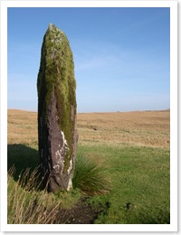 What made our ancestors place these huge monoliths? Why, along with their numerous burial cairns, were they placed high up in these hills? Why was this a significant place for the ancient Briton? Archaeologists and historians speculate and hypothesise but like much of ancient history, with the lack of documented records, it can at best be an educated opinion rather than stated fact.
Leaving the standing stone behind I headed up over two fine peaks, only encountering two other walkers on the way. Then heading down to the line of an old mineral railway. that started high up in the hills by a series of small quarries before descending to the level above the hamlet of Glyntawe. The hundreds of miles of abandoned lines around our country are under utilised, admittedly many have been turned into paths or cycleways but many more lie forgotten and overgrown.
This line I suspect was under-promoted although it was clearly shown on the map. For some reason part of it was left out of the open-access area indicated on the map although the open-access continued either side of the line. This potentially prevents anyone following its course along the full length of the valley. So I was “forced to trespass” by continuing along the line, although others had clearly preceded me, to my destination of Coelbren.


![Reblog this post [with Zemanta]](https://i0.wp.com/img.zemanta.com/reblog_e.png)

