walking


{{de|Grosser Krottenkopf von Westen (Allgäuer ...
Image via Wikipedia

I am stunned to find out that I have won an adventure holiday for two to the Allgau Alps in Bavaria. This was after I entered a competition in the July issue of TGO magazine.

One of my customers comes in to post at least half a dozen competition entries a week and once told me that the number of entries to these competitions is relatively small so you have a high chance of winning. So it has proved because this is the second prize I have won with TGO this year. Admittedly my previous prize was a less glamorous win – two tickets to the Outdoor Show.  Most of the time all I have to do is answer a simple question and press the send button on my email entry.

So I am now looking forward to five nights at a mountain lodge run by a company called My Peak Potential. The activities that are on offer look great, I am particularly tempted by the gorge experience but really want to try out some of the Klettersteig (via Ferrata) routes in the area. The food is cooked by a local chef some good Bavarian specialities will be sampled washed down by German beer. Great!

If anyone has been to this part of Germany I would be interested to hear of any recommendations,  particularly for day walks in the area.

Reblog this post [with Zemanta]

Walk-it-banner

The Lochailort Pyramids

When asked to name the classic ridge routes in the Scottish mountains most hillwalkers would list Aonach Eagach, CMD arete, Forcan ridge and the Skye Cuillins among them. I suspect few would mention the Lochailort Pyramids hidden away in Moidart. That’s a shame as they offer a delightful day out in the hills, albeit one that does not involve tricky scrambling or nerves of steel to edge along exposed sections. Even better their relative anonymity means that you will have the three Corbett peaks and their interconnecting ridge virtually to yourself. Even on a fine Easter Sunday there were few out on these hills. In comparison, the Aonach Eagach would have been more crowded than the M6.

Open hillside to An Stac

 Starting from the small car park at Inverailort our walking club split in to two groups with the larger group opting to undertake the horseshoe route, whilst my smaller group headed off to tackle An Stac. Comments from walkers that had already climbed An Stac included, “It is relentlessly steep” and “I know if I climb An Stac I won’t want to continue beyond it.”

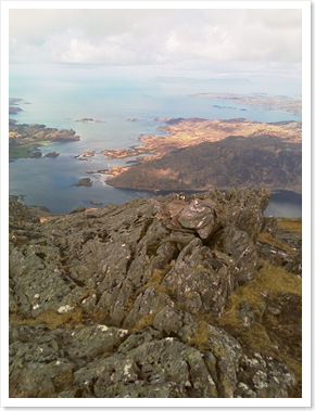
Yes, the north ridge of An Stac is steep but I have been up steeper. From the col below it does look at though the climb will go on for ever, but on a clear day you are rewarded with views of the azure clear waters of Loch Ailort and the Sound of Arisaig. Beyond An Sgurr on the Isle of Eigg points stubbornly upwards from the low lying island around it. Even further away are the proud peaks of Rum with a halo of cloud encircling them. Concentrate on these visual diversions and you will soon find yourself topping out on the summit, out of breath and ready for lunch. Loch Ailort and the Sound of Arisaig beyond

The real killer of this walk is the steep descent to the col on the south side, a 250m knee crushing descent when faced with an almost vertical climb of 160m up to the Bealach an Fhiona. There we decided we did not have enough energy to climb Rois-Bheinn and descend to the bealach again before tackling the third Corbett of Sgurr na Ba Glaise. Not wanting to descend to the road beyond Rois-Bheinn, instead wishing to prolong the delights of ridge walking on such a fine day, we headed straight up Sgurr na Ba Glaise instead. Fine views deep inland greeted us with the snowy top of Ben Nevis dominating.

Picking our way around the rocky outcrops along the ridge we continued round to the Druim Fiachlach enjoying gazing past its crag deep into the corries below. The small lochan below the Druim’s midpoint was our marker to strike north-west down heather clad slopes towards Inverailort, the white Lochailort Hotel our navigational beacon luring us with the promise of cold beer. How I managed to find the soggy parts of this hillside as I slid on my backside not once but three times I am still not sure. Reaching the valley floor with damp, tender and tired thighs was a relief. 

Reblog this post [with Zemanta]

Walk-it-banner

 Glencoe Lochan Trails

Wanting to take advantage of unexpected good weather but unable to head high, I opted for a stroll  with the family around a local hidden gem. This is a popular spot for some gentle afternoon exercise and on this occasion even a small tour bus had disgorged its foreign visitors, cameras poised, to enjoy the pleasant woodlands at the foot of the Pap of Glencoe. Even so, a feeling of tranquility remained as we wandered around the small man made lochan, the perfect mirror for the white-capped peaks of Beinn a’Bheitr. Glencoe Lochan 3

This was also the perfect opportunity to try out a new GPS combo with my PDA, as there is a popular geocache hidden at the head of the lochan. If you haven’t tried geocaching then I recommend following the link for more information. It makes a pleasant diversion from time to time and I may write more about it in a future blog.

If you have spent a gruelling day on the Glencoe peaks, had your legs turned to jelly along the Aonach Eagach ridge or need a gentle aperitif before supper at the Clachaig Inn this is definitely the place to meander for a few minutes. 

You can see full route details at the Walk Highlands website.


Reblog this post [with Zemanta]

Walk-it-banner

The Ballachulish Horseshoe

Whenever I drive home from Fort William my eyes are always drawn beyond the Ballachulish Bridge to the scimitar ridge of Beinn a’Bheitr above. The curving knife-edge neatly framing the forestry plantations as they plunge down in to Glenahulish below.

Whatever the season, whatever the weather you always notice something different about these mountains. The setting sun glinting from the wet rocky ridges following a late afternoon shower. The Dragon’s tooth menacingly erupting from the primordial swirling mists carpeting the corrie floor. Sweeping, seemingly virgin, snow fields, as crisp as freshly pressed cotton laid out over the ridge and flowing down into the high corries below. What simple delights the crowds miss as they steam across the bridge eyes firmly fixed on the craggier delights of Glencoe. Beinn a' Bheithir from across Loch Leven

Although I have climbed the two Munros of Sgorr Dearg and Sgorr Dhonuill before, I am not so obsessed with bagging that I would refuse to climb a peak again before completing a round. With limited, low level walking over the winter this was the perfect chance to give some underused muscles a workout.

There is no better way to reach the main ridge then climbing from the north-east to the minor top of Sgorr Ban. In fact this is the recommended route in “Scrambles of Lochaber”, describing it as a straightforward scramble with beautiful views. Instead, as I tramped up the boggy ground to the start of the scramble I had to content myself with imagining the Glencoe summits without their cloudy shroud. The way up is always clear with a few interesting moves but little exposure, making it perfect for anyone who has never scrambled before. As I was plodding along, my companions ahead merged in to the grey fog, spectres floating in and out of sight. There was a real feeling of solitude as I was enveloped in the murky silence.  The fog thickened on the approach to Sgorr Dhearg, the edge of the cornice barely visible and only a hint of the corrie beyond.

A quick check of compass and map at the summit gave us our bearings to descend towards the col before the stiff climb up to Sgorr Dhonuill. At the col it seemed that we might have to descend to Glenachulish as the way ahead seemed to be blocked by an extensive snowfield. Both ice-axe and crampons had been consigned to the car boot before setting off, deemed to be unnecessary on such a day. Fortunately, the snow was limited and where it needed crossing it was soft enough to walk through or in unexposed areas presenting no particular danger. 

Beyond the summit of the second munro we opted for the quicker descent down the “Red Scree Gully” rather than continuing around the ridge. Although steep and unstable in places the gully soon leads to a well engineered path and down into the heart of Forestry Commission land and the tracks leading to the small parking area. A pre-arranged driver to ferry us back to our cars meant we avoided the long trek via St John’s Church to Ballachulish.


Reblog this post [with Zemanta]

Walk-it-banner

Through the Torridon mountains

This was a seemingly innocuous route on the map but was to prove a long and tiring day. The title should more accurately be, “Round the front of Beinn Alligin and Beinn Dearg before going round the back of Beinn Eighe having followed the full length of Liathach.” Although accurate such a title is unnecessarily cumbersome.

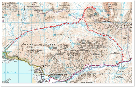
I joined the other members of the hillwalking club at Torridon Youth Hostel, where they were based, for the first of their away weekends this year. The mountain forecast included gale force winds and snow blizzards so I opted for the lower level walk rather than attempt the Horns of Alligin with the more overoptimistic members. This may have been a low level walk but it certainly wasn’t a level one. As we headed out on the National Trust path up Coire Mhic Nobuil, I was lulled into a false sense of an easy day ahead. Having crossed the river, the path soon deteriorated to the rough, roller coaster like path that is normally encountered in the Highlands. Even so, we still made speedy progress to Loch Grobeig where we departed the path to head across open hillside to the path skirting Beinn Eighe. With the cloud base so low we were unable to enjoy views of the magnificent mountains around us.

 Track-Torridon

Tramping through wet, soft snow took us alongside the crashing waterfalls given fresh impetus by the torrent of water falling from the skies, before a sharp rise into the flat-bottomed Coire Mhic Fhearchair. This imposing mountain amphitheatre provided no protection as the wind funnelled driving rain in through its North-West mouth. Somewhere in the cloud the Triple Buttress loomed down upon us, we could only guess at its grandeur but could still feel its rocky menace lurking unseen.

Triple Buttresses of Beinn Eighe, ScotlandBy now, with sheets of water draining off the mountainside, we realised that crossing the river on our return would be nearly impossible. Sure enough our way across was blocked by a heaving mass of water ready to knock any foolish walker, trying to ford it, from their feet. At the end of a long day your heart sinks at such an obstacle and the prospect of a long diversion, or even having to retrace your footsteps. Will weary legs carry you further than originally intended? Fortunately by following the east bank of the river, although boggy for much of the way, eventually led tired bodies to a rough path down to the Glen Torridon road and a short walk to our shuttle cars. A long sodden day but one with a great sense of achievement even though no mountain top was conquered. Reports from the hostel told us that the hardy low-level walkers had in fact climbed higher than those that had headed to Beinn Alligin.

Reblog this post [with Zemanta]

Countryside-in-crisis-banne

Highland Post Buses Axed

Another lifeline service for rural communities in the Highlands will disappear in April as Royal Mail axes five post bus routes serving some of the remotest areas in the country. Areas such as Applecross, Torridon and Tongue will be hardest hit by the cost-cutting exercise where no real alternative public transport links exist.

Torridon village seen from Loch Torridon shore...

Although only just over 3000 journeys were made along these routes last year, this would suggest that they were well used by the small, scattered communities. Yet Royal Mail has decided to save just £12,871 a year by cutting the five routes, even though they seem to have made no effort to seek subsidy from the Highland

Council.

Royal Mail will still need to drive along these routes in normal post vans so why the need to cut such an important service that will save so little. If they need to make savings then they should perhaps look at the remuneration of their superannuated  Chief Executive, Adam Crozier.

There must be enormous potential for services like these amongst the walking fraternity. For example, the Achnasheen to Diabeg service runs through the heart of Torridon and could easily provide drop-off points for walkers wanting to undertake walks on many of the mountains in that area. Yet, there is no publicity of the service locally or within the walking community. You have to search hard on the Royal Mail website to find any mention of post buses. Just a little bit of marketing could mean additional use, allowing the service to continue for the benefit of both walkers and local communities.

Reblog this post [with Zemanta]

An interesting campaign has been launched by Roseanna Cunningham, the SNP Member of the Scottish Parliament for Perth and Kinross. In a feature in yesterday’s Sunday Times she reveals a plan to establish a Pilgrim Way from Iona to St Andrew’s across 200 miles of some of the most beautiful countryside in Scotland. Along the way walkers would retrace some of the steps that St Columba‘s 6th-century monks trod as they fanned out from Iona Abbey taking the Christian message to the people of Scotland.

The plan is to link many of the small villages, settlements and ancient churches of Argyll, Stirlingshire, Perthshire and Fife. Not only would it be a stunning walk for its scenery but it would be a fascinating trail back into the country’s early Celtic history. The thought of a long-distance trail that takes in islands, ferry journeys and quaint little villages really excites me.

The idea is not just to celebrate our countryside and heritage but to act as an economic stimulus for many of the small communities that would be on the route. I know from living in a village that lies on the West Highland Way what a lifeline walkers and tourists are for local businesses and people. The Sunday Times article emphasises the cross-denominational support the plan has already received but it will also need support from the walking community as well. A Facebook group, Campaign for Pilgrim Way (Scotland), has already been set up where you can register your support.

Reblog this post [with Zemanta]